Tuesday, April 23, 2013

Happy happy birthday, Mary Trish!!! =)

Reposting from http://notsolittlewomen.blogspot.sg/2013/04/happy-birthday-mary-trish-grace.html
 
Once you've thrown up on someone, you have a bond that will last a lifetime. I think that's the secret to a lasting friendship. Haha! I still blame you for making me and Carmi finish an entire bottle of El Hombre Tequila, by the way. Blech. NEVER. AGAIN.

Now that THAT's out of the way...ahem...here comes the randomly put together (sort of) lovey foofey part. Brace yourself, Mary Trish.

There are people who momentarily hold a position of importance in one's life, but in the grand scheme of things are really just passers-by, and then there are the seemingly inconspicuous ones who just linger and hover in the background, blending into the context and reading your text messages while you're asleep, and demanding to know what your dad texted you. (Guess which category you fall into.)

I remember at some point during college or law school, we were in a cab on our way to Eastwood, sitting quietly in the back and staring out opposite windows, and it dawned on me that the best friends you can ever have are those you can be sit in comfortable silence with. There is a certain level of ease borne out of the lack of any inherent need to contextualize everything. Most things need not be said, and even from a literal ocean away, you can just sense that something's amiss, without needing to be told.

I could not be more thankful we were randomly thrown into Eliazo Hall's Room 305...even though you made some Cervinian think I was stalking him because you used my mIRC account to add him as a friend when I'd never even met him, you told a friend I didn't want to live with her and she ended up not talking to me for a looooooooong time, you attempted to drop out of law school in our first semester of law school to supposedly become a nurse, AND you converse with random animals in your sleep (and that's just the tip of THAT particular iceberg).

Here's to the past fourteen, and to more crazy years of friendship, Mary Trish. See you on Thursday. =)

Thursday, February 09, 2012

O.M.G. What happened to my blog fonts???

Comic sans??? Seriously??? There are very few fonts that annoy me more. What happened to my old font selections??? Now I'm stuck with the generic ones. =((

Wednesday, January 18, 2012

Louis Philip Kee Brazilian Blowout Voucher for sale (Php4,200)

Hey guys. I'm selling my Louis Philip Kee Brazilian Blowout voucher. I bought it from Deal Grocer last year. I recently decided I like my hair as it is, so I'm selling the voucher for the same price I bought it for. Anyway, let me know if you're interested, or if you know anyone who is.

Idiot's Guide to Ilocos


And so after all the stress of the past few weeks, Tita Susan, Tito Efren and I have decided to go on a little four-day vacation to Laoag, Vigan, and the surrounding areas (with Jem and Shayne, of course). It was actually supposed to be a solo trip for me, and then with Tita Susan, but Tito Efren and the others decided to tag along. So anyway, I worked on our itinerary yesterday, and I must say, the Ilocos provinces: WOW. They’re blessed with some of the best natural scenery and man-made architectural gems. No wonder they’re so proud of their heritage. I would be too. 

Anyhow, in case it will help anyone trying to plan a trip there, I’m sharing our itinerary and a little FYI pamphlet I prepared for the oldies, for a bit of historical background. I’ll add pictures later kung sipagin ako.

NOTE: I did not write the historical background part. I just edited some parts for grammar of clarity. Well, I'm in the process of editing. Most of it, I borrowed from http://www.worldtourist.us/ilocosnorte/laoag.html. The rest, I compiled from the following websites. (This is a post-compilation best-efforts list. If I missed anything, please let me know.)

http://www.pinoytravelblog.com/travel-destinations/ilocos/685/touring-ilocos-without-a-car-part-1-from-manila-to-laoag (This series of articles was VERY helpful. Particularly since I was supposed to travel alone without a car.)

Anywaaaaaaaaaaayyy… 

ITINERARY FOR ILOCOS TRIP

  • DAY 1

7:55 pm            – ETD MNL-LAO flight (5J-404)
9:00 pm            – ETA Laoag


  • DAY 2

NOTE: Morning activities optional.

8:00 am            – Breakfast at Saramsam Cafe
9:00 am            – Museo Ilocos Norte (Php20 entrance fee) / Ilocos Norte Capitol
10:00 am           - St. William’s Cathedral / Sinking Bell Tower
11:00 am           - Balay da Blas (Wait for Tita Susan et.al.)

12:00 nn            - Lunch at Saramsam Café
1:00 pm            - St. William’s Cathedral / Sinking Bell Tower
2:00 pm            - Museo Ilocos Norte / Ilocos Norte Capitol / Tobacco Monopoly Monument
3:00 pm            - Sarrat (15 mins east of Laoag) – Sta. Monica Church
4:30 pm            - La Laz Sand Dunes (20 mins west of Laoag)

6:00 pm            - Dinner at Fort Ilocandia

Driving directions: Follow the main road and make a left on the airport road, proceed until you see the Northwestern University on your right. Make a left on the road in front of the University, and make a right towards the entrance to Fort Ilocandia Resort.

8:00 pm            - ETA Balay da Blas


  • DAY 3

7:00 am            - Breakfast at Balay da Blas
8:00 am            - ETD Balay da Blas
                           (En route: Patapat Viaduct)                 
9:30 am            - Pagudpud (until lunchtime) (1.5 – 2 hours from Laoag) – Saud Beach

12:00 nn            - ETD Pagudpud
12:30 pm           - Paraiso ni Anton (running waters through a lush green forest leading to a statue of the Virgin Mary)
- Maira-Ira Beach (“Blue Lagoon”) – Sitio Gaoa, Balaoi, Pagudpud
  • Timmangtang Rock (U-turn, right on smaller road; male rock)
  • Bantay-AbotCave (female rock)
    • Collectively called lovers’ rock
  • Dos Hermanos
- Kaibigan Falls (optional; 30 minute trek)
- Bangui Windmills (1.5 hours from Laoag, 30 mins from Pagudpud)
- Kapurpurawan Rock Formation
- Cape Bojeador Lighthouse (40km northeast of Laoag) – 30
- Pasuquin Saltmakers (optional)
                        - Bacarra Church and Bell Tower Ruins (15 mins from Laoag)
6:00 pm            - Dinner at La Preciosa (Rizal St., Laoag City, Ilocos Norte, 2900)
   Tel.: (+6377) 773-1162 / 2159
8:00 pm            - ETA Balay da Blas
6:00 pm            - Dinner at La Preciosa (Rizal St., Laoag City, Ilocos Norte, 2900)
   Tel.: (+6377) 773-1162 / 2159
8:00 pm            - ETA Balay da Blas


  • DAY 4

7:00 am            - Breakfast at Balay da Blas
8:00 am            - ETD Balay da Blas
9:30 am            - Bantay Church (town before Vigan)
11:00 am           - Baroque Church of Sta. Maria (3 hours from Laoag)

12:00 nn            - ETA Vigan (1.5 to 2 hours from Laoag) – Lunch at Café Leona (Calle Crisologo - Vigan City, Ilocos Sur; +63 (77)722-2212)
1:00 pm            - Calle Crisologo / Crisologo House / Syquia Mansion / Quema House / V. Singson Encarnacion House / Grandpa’s Inn
4:00 pm            - St. Paul’s Metropolitan Cathedral
5:00 pm            - Burgos National Museum
7:00 pm            - Dinner at Hidden Garden / Lilong & Lilang Coffee Shop (Brgy. Bulala Centro, Vigan City; (63)(77) 722-1450; Francis Flores, owner, 0921-664-0737
10:00 pm           - ETA Balay da Blas

Other places we can go:
·         Chavit’s Baluarte Zoo
·         Burnayan (pottery)
·         Plaza Salcedo
·         Plaza Burgos

  • DAY 5

8:00 am            - Breakfast at Balay da Blas – Don’t forget to check out!!!
9:30 am            - ETA Paoay (15-20 mins from Laoag)
·         Malacañang of the North
·         Paoay Lake
·         Paoay Church

12:00 nn            - Lunch at Herencia Café – in front of Paoay Church (McArthur Street, Bgy. 14, Paoay, Luzon, Philippines; 077- 614 -0214)
1:30 pm            - Batac – Marcos Museum
3:00 pm            - Currimao – Nipa Beach Hut Resort
5:00 pm            - Badoc – Juan Luna Shrine
                        - Badoc - La Virgen Milagrosa Shrine
6:00 pm            - ETA Balay da Blas

7:00 pm            - Leave for airport
9:30 pm            - ETD LAO-MNL (5J-405)


THE PROVINCE OF ILOCOS NORTE

Ilocos Norte is located on the northernmost edge of western Luzon. Its boundaries are formed by the Babuyan Channel on the north and its sister province, Ilocos Norte, on the south. To the west are the tribulent waters of the South China Sea, while the eastern borders are formed by part of the Cagayan Valley, Abra and the Mountain Province. A well-paved coastal highway connects the province with the rest of the country.

Ilocos Norte has a total land area of 3,400 square kilometers. It is composed of 22 municipalities with 477 barangays. The province's population was 514,000 by the census of 2000, and since 1999 its governor is Ferdinand R. Marcos, Jr. It was made a separate province in 1818. The province is noted for being the birthplace of former Philippine President Ferdinand E. Marcos, who led an authoritarian rule over the country during the later half of his incumbency. Ilocos Norte has always been Marcos territory and the family enjoy a moderate amount of popularity in the province. Even before one reaches the capital, traces of the "great Ilocano" are unmistakable.

Long before the Spanish galleons came to the Philippines, the coastal plane of Ilocos Norte was already flourishing with business carried out by the Chinese and Japanese traders. The first Spaniards to reach the region were Juan de Salcedo and his men, who were tasked to explore the coast of Luzon north of Manila in 1572. The largest concentration of people that Salcedo found was in Laoag along the Padian River, and Salcedo gained their friendship after initial skirmishes. Although the presence of the Spanish soldiers may have seemed fleeting to the Ilocanos, Salcedo's exploration marked the beginning of Spanish colonization of the region.

Agriculture is the main source of livelihood in the province, all lands for cultivation can be planted with rice, corn, garlic, onion, sugarcane, tobacco, and cotton. Ilocos Norte is also noted for its various cottage industries, among which are cloth weaving, pottery-making, blacksmithing, woodcarving and furniture making. Its ethnic population is overwhelmingly Ilocano. Unlike the rest of the region, however, the Roman Catholic Church does not predominate. The Aglipayan Church, Iglesia ni Cristo, and other Protestant groups have strong followings, as well as, animism and non-religiosity. The climate is characterized by two extremes: very dry from December to April and very wet for the rest of the year. The average temperature in Ilocos Norte is 81 deg F. May is the warmest month, with an average temperature of 83 deg F, and December is the coldest.

Laoag City

Laoag City, the capital city of Ilocos Norte, is 463 kilometers north of Manila. The municipalities of San Nicolas, Paoay, Sarrat, Vintar, and Bacarra form its boundaries. The foothills of the Cordillera Central mountain range to the east, and the South China Sea to the west are its physical boundaries. Flourishing along the bank of the Laoag River, it is the nerve center of the province and the seat of politics, business, commerce, education and religion. It became a 2nd class city in 1965. According to the 2000 census, it has a population of 94,466 people in 19,751 households.

"Laoag" (Ilocano for "the place of light or clarity"), is an old, flourishing settlement known to Chinese and Japanese traders when the Spanish conquistador Juan de Salcedo arrived at the northern banks of Padsan River in 1572. Augustinian missionaries established the Roman Catholic Church in the area in 1580 and designated Saint William, the Hermit as its patron saint. Pedro Almazan crowned himself king of Laoag in 1661 in a bid of insurrection and protest against Spanish tax mandates. Other rebellions flared throughout colonial times, including against Spanish tobacco monopoly in 1782.

Laoag is an 9 to 10 hour drive from Manila depending on the traffic or how fast you are going. Provincial buses also provide transportation from Baguio City, Manila, and a number of other cities. There are air-conditioned buses that leave their Manila stations for Laoag. The buses, which leave on scheduled runs, do stopovers at designated points along the route for refreshments and other necessities. Laoag International Airport services flights to and from Taiwan and some charter flights by Philippine carriers. It is a 1 hour flight from Manila. The town experiences the prevailing monsoon climate of Northern Luzon, characterized by a dry season from November to April and a wet season from May to October, occasionally visited by powerful typhoons.

The Landmarks & Attractions of Ilocos Norte
  • Juan Luna Shrine
  • Fort Ilocandia Resort Hotel
  • Paoay Church
  • Marcos Mausoleum and Museum
  • St. William's Cathedral & Sinking Bell Tower
  • Museo Ilocos Norte
  • Bacarra Church & Bell Tower Ruins
  • Malacanang of the North
  • Salt Making in Pasuquin
  • La Virgin Milagrosa Shrine of Badoc
  • Currimao's Nipa Beach Resort
  • Sarrat's Sta. Monica Church
http://media-cdn.tripadvisor.com/media/photo-s/01/d5/30/6b/museo-ilocos-norte.jpg


MUSEO ILOCOS NORTE

Located in the downtown area of Laoag City and just close to the provincial capitol and about a block away from the town plaza is the Museo Ilocos Norte. One of the best ways to get to know Ilocano culture is by visiting the museum. The museum is housed in the restored historic Tabacalera warehouse, which was a factory of sorts for tabacco back in the Spanish Era. The museum was primarily designed to bring a sense of pride to the citizens of the province. It showcases the varied ethnicity and multi-faceted cultural heritage of the Ilocano people. It is one of the few attractions in Laoag City which is most visited by school children, visitors, and tourists.

The museum is nicknamed, "Gameng," from the Iloco word meaning treasure. It symbolizes the wealth of Ilocos Norte. There is an assortment of items displayed on both floors of the two-storey building. Before you exit out of the museum, you will find a small giftshop which sells an assortment of native products and handicraft of Ilocos Norte, and a few books and other publications written about the province. There is a minimal fee charged to view the contents of Museo Ilocos Norte. The museum is opened during office hours in the morning and afternoon of the work week, however, it is closed at noon time which allows it's staff time for their lunch break. The symbol of the museum, a many-rayed sun, was taken from one of the finials at the back of the 19th century church in San Nicolas. 

http://farm5.static.flickr.com/4030/4674605725_eb27b0c98f.jpg


http://farm5.static.flickr.com/4070/4632596272_c6a2d68512.jpg
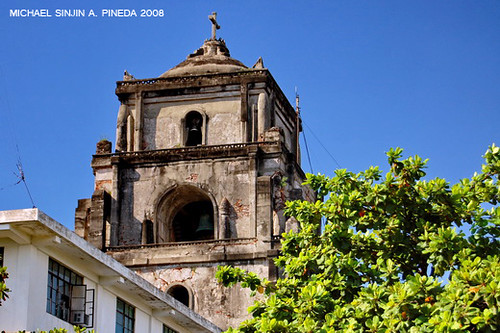

ST. WILLIAM'S CATHEDRAL & SINKING BELL TOWER

A chapel of wood and thatch was originally built on the same site when the Augustinian Friars founded the parish in 1580. Later in 1612, foundation for the replacement of the church was laid by the friars and construction of the cathedral with Italian Renaissance design began. The church was damaged by fire in 1843 and repaired through the efforts of the Obras Publicas under the supervision of Engr. Antonio de la Camara and Fray Santiago Muniz from 1873 to 1880.

The reconstructed church has a unique two-storey facade held by four pairs of coupled columns and was called the St. William's Cathedral. The deeply recessed niche shows the image of Saint San Guillermo. It is the one of the biggest cathedrals in the country and became the seat of the Diocese of Laoag. In 1898 it was occupied by Revolutionarists and also by the American forces in 1899. The cathedral was the site of the Diocesan Congress in 1932 and 1949.

Located 85 meters away is its bell tower which has sunk to the grounds and leans slightly. The 45 meter high bell tower is one of the tallest edifice built in the province. When the tower was newly erected a person on horseback can pass through its door freely. Today, a person of average height could hardly pass without stooping.


http://farm6.static.flickr.com/5087/5288952216_eeeabcd38c.jpg
https://blogger.googleusercontent.com/img/b/R29vZ2xl/AVvXsEgEQqzqLBwDByLWby2C_Uu6zdYy5q0x7AdJ1K-bezvx_t3uoekNaFHS-ABcTM8y3GPAVznPsQydPCVls1g7ZE9rbeXXXqfC6O4Cd6ZAtIiehexfz4FWTAIGmgWUeuvG9hhb-bjG/s1600/aurora%252Bpark%252Blaoag%252Bcity%252Btobacco%252Bmonopoly%252Bmonument%252Bilocos%252Btour.jpg

TOBACCO MONOPOLY MONUMENT

When the Spaniards discovered that the land and climate of Ilocos is perfect for growing tobacco, they forced the people to plant only tobacco and no other crop. The sakadas were also forced to sell the tobacco leaves only to the Spanish government. This has lead to numerous resistance among the locals. There were also stories of untold abuses done by the authorities. For one hundred long years, 1781 until 1881, the tobacco monopoly existed in Ilocos. A period of dark history in Ilocandia.

It was only in 1881 when King Alfonso XII lifted the tobacco monopoly. The people of Ilocos then erected the Tobacco Monopoly Momunent as a thanksgiving to the Crown of Spain for recognizing the stuggles of the Ilocano people against the Monopoly.

The tall yet graceful monument is located right at the center of
Laoag City plaza, in front of the Provincial Capitol.


http://farm4.staticflickr.com/3480/3212135856_d8ff6efa50_z.jpg

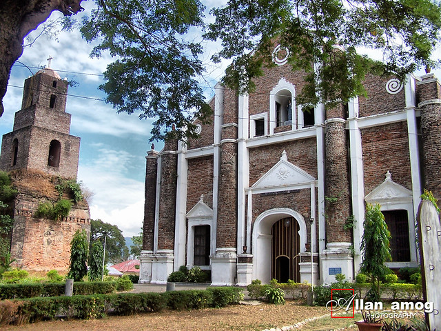
SARRAT'S STA. MONICA CHURCH

In the town of Sarrat is a beautiful red brick church of Baroque and Neo-Classical style called the Sta. Monica Church. Irene Marcos, the daughter of former Philippine President Marcos, was married to Gregorio Araneta in a fairytale-like wedding in the church complete with red carpet stretching for kilometers. In the Philippines, it was termed the "wedding of the century." However, a little more than two months later, on Aug. 17, an earthquake of Intensity 7.6 ravaged Ilocos Norte and destroyed the altar and belfry of Sta. Monica.

The church is located some 7 kilometers to the east of Laoag City proper. It is an all-brick church with buttressed walls and a 3-level brick bridge and staircase connects the church to the convent making it one of the unique features of this church. The Sta. Monica Church, convent and bell tower began construction in 1669 and were completed in 1679. Rebuilt after a fire in 1817, the complex was again damaged by fire in 1882 but was rebuilt and finished in June 1896. The church features a 137-meter nave that is the longest in the country, according to the Cultural Center of the Philippines’ Encyclopedia of Philippine Art. It follows a simple rectangular plan and another outstanding feature of the church is its unique system of roof trusses.

Like the bell tower, the convent stands apart from the church. Separate towers and rectories are characteristic of the province, a measure to minimize damage during earthquakes. At the ground level of the convent are housed memorabilia, books and photographs connected with the history of the parish. The ruins of Sta. Monica Church in Sarrat include a torture room where two huge brick-encrusted pillars dominate. Melvin dela Cuesta, a Filipino historian, said these pillars were used during the Spanish regime to hang Filipinos accused of treason and other high crimes.

https://blogger.googleusercontent.com/img/b/R29vZ2xl/AVvXsEig8pqtUmgInZ485_PW3fT317RZj4X6GSE8tyRgmlXNrC9D-7ZlyfqiJNxeENyWFrVCyFgvkvbqruT1yj5zmI9o4DGqHjkCiDPckMXmsIIofsi2MLgbVwOEzaR2SHIBHQr54gkTHw/s1600/sanddunes_laoagcity.jpg

La Paz Sand Dunes is a unique attraction in the city of Laoag for being a sandy coastal desert with an area of 85 square kilometers. This is considered to be a National Geological Monument because of its uniqueness being a desert environment. La Paz is just a part of a long stretch of the Ilocos Norte Sand Dunes. It spans from Currimao to Pasuquin. This is locally called Bantay Bimmaboy in which they perceive that the dunes resemble the shape of pigs.

The sand dunes were formed by the interaction of the wind, sea and river that together cause erosion and deposition. The height of the sand dunes ranges from 10-30 meters. Its pretty amazing to see this from a horizon with the South China Sea. There are exciting activities that can be done here aside from trekking for an hour to traverse the entire stretch of the beach, one can drive a rugged 4-wheel vehicle or the exciting all-terrain vehicle. The latest craze is the sand boarding where one can use a board to slide down the dunes. This site is accessible by tricycle and jeepney and its just 15 minutes away from the city proper.

With these activities, one can call it a desert safari just like what I had experienced from Dubai. This was my visit to the site just right after arriving from the Middle East in which I hosted a Canadian friend’s visit to Ilocos. I took Romeo here to experience the desert. I did not fail, he truly enjoyed it. He ran, jumped and climbed the sand dunes on bare foot feeling the heat underneath.

This is another world class treasure of Ilocandia. It was used to be a shooting site for several local and international films. Himala and Panday are the classic local movies that were shot here. And of course segments of the
Hollywood films such as Mad Max and Born on the fourth of July where Tom Cruise had a fight scene and rolled over the sand dunes.


https://blogger.googleusercontent.com/img/b/R29vZ2xl/AVvXsEglRMz5W9gilkC87E8oJegoy_6oE6IGUlweYBOXBtj8-jUxQCQDN0eZZAuownueWMK99NuFjCvURSNNci1iyOmrIwFbB7Kqm7xA59s5PehsCK_TfhXzevfNxeO4yRkaLuyPwtkg/s1600/IMG_2826.jpg

http://media-cdn.tripadvisor.com/media/photo-s/01/c6/52/e7/one-of-fort-ilocandia.jpg
FORT ILOCANDIA RESORT HOTEL


The resort is located in Barangay 37, Calayab, and about 9 kilometers from Laoag City. It is the only first class property of its kind in the province of Ilocos Norte. The hotel is sprawled over 77 hectares of land at the middle of sand dunes, prime forests, and two kilometers of fine sandy beach facing the South China Sea. It is situated on the northwestern tip of the island of Luzon. Laoag City and Laoag International Airport are accessible by a 10-minute ride from the hotel.

The Fort Ilocandia Resort complex is composed of 5 buildings all inspired by Spanish colonial architecture and finished in coal red bricks. It has guest rooms with private balconies offering a panoramic view of the sea. These rooms have features and qualities of Ilocano century-old living quarters and constructed to accentuate the antiquity of a colonial house.

The main building houses the lobby, a number of restaurants, shopping arcade, casino, discotheque, and a glass-topped atrium where you can relax as you sip your favorite drinks, tea or coffee. For those who love Asian cuisines, Lucky House and Golden Pavilion are the best places to dine. It offers the finest Cantonese dishes and one can find delicious dishes from Korea, Japan and Taiwan. At the Sunset Bar which is located at the beachside you can have a drink and after which you can dine in a Spanish Restaurant, or CoCo Lobster where you can enjoy authentic Filipino cuisine. After your dinner, you can visit the Casino Filipino at the second floor. It is open 24 hours a day with multi-lingual attendants. The gaming area includes more VIP game rooms to satisfy your appetite for thrill. At the Passion Night Club and Karaoke glamorous shows are held every night. There are VIP rooms where guests can show their singing prowess or none of it, and have a fun and relaxing time.

Hotel facilities of Fort Ilocandia include an Olympic-sized swimming pool, seven function rooms, video arcade, tennis court, badminton court, gym and sauna, driving range, golf course, paintball, beach volleyball, jet ski, sea donut, wind glides, sailing boat, bodyboard and pool toys. The guests may also indulge in various recreational activities such as wind sailing, archery, shooting, horseback riding, wind gliding/wind surfing, canoeing, open sea fishing, snorkel diving, scuba diving, and rafting, among others. The resort also has a world-class 18-hole golf course with international standards and a perfect design to challenge one's playing skills. The golf course, with numerous trees built along Lake Paoay was designed by PGA champion, Gary Player for the late President Marcos. It measures 6,518 yards from the blue tee with a par of 72. Added hazards are the century-old fruit bearing trees and man-made ponds and lake.

The hotel's red brick facade and roofs beautifully contrast with white round windows. Clearly, it's inspired by the architecture of the colonial Spanish or Spanish Moroccan style. There is an impressive and immense fountain and well-maintained gardens and flowering plants-lined walkways. The rooms that spread out in four other two-storey buildings include 233 standard rooms; 25 deluxe rooms; eight junior suites; and two presidential suites. All of them have aircon units, cable tv, telephones, and a bathroom with hot water. Fort Ilocandia Resort is without doubt one of the most interesting places in northern Luzon and is perfect for pleasure seekers because of its distinctive and naturalistic appeal.


https://blogger.googleusercontent.com/img/b/R29vZ2xl/AVvXsEhBfRO36V0Fqbr9lg20MKE0OzsIt74bAEj-3Z8EtHKgSQ6PBSJn5TzpGpEt8l2JtbrB-7vMLmvZZShpwn_BhopysAQlG0vJOw9oLVFd_lHa-LT8sWRyDkde7zEpFDxQYjORjxiD/s320/Patapat+Viaduct+Pagudpud+Ilocos+Norte+B.jpg
PATAPAT VIADUCT

The Patapat viaduct is considered as the 4th longest bridge in the Philippines and the second northermost road of the island of Luzon. It is like a winding bridge beside the cliffs of the Cordillera Mountain Range It is about 1.5 kilometers long and elevated around 30 M above the sea. It connects the Maharlika Highway to Cagayan province. It was built for the purpose of minimizing landslide. Other buses bound to other northernmost province of the Philippines take this route.

Also called as the “French Riviera of the North” for this magnificent coastal drive. You can just park your vehicle and take photos of the vast northern blue sea and flying birds along the coast. Like what we did on our way to Paraiso ni Anton. You shouldn't miss the opportunity to witness the view of the south china sea waves that hit big rocks which was indeed breathtaking.


Saud Beach - http://lh5.ggpht.com/_bJKz4lWVpfo/TUcJ9c6wIKI/AAAAAAAAElU/nflPOcfvlFA/Saud%20Beach%20in%20Pagudpud,%20Ilocos%20Norte%20-%20JustAnotherPixel.net%5B2%5D.jpg
Maira-Ira Beach / "Blue Lagoon" - http://www.thinkphilippines.com/pictures/blue-lagoon-maira-ira-beach-philippines.jpg
Timmangtang Rock Formation - http://farm6.static.flickr.com/5174/5525782508_a3b0e2539e_o.jpg
Bantay-Abot Cave - http://manilenio.com/wp-content/uploads/2011/10/Bantay-Abot-Cave-Ilocos-Norte.png
Dos Hermanos Islets - https://blogger.googleusercontent.com/img/b/R29vZ2xl/AVvXsEgHApAUfpOPQbU1ZeWdDvh0ePF_R6nj2FeMlJmyKeECXCaWkqEp6aF8D9KNzH1nLn-SheznWgp94pXuASiomWlAISmTonrX005OK8FPzBsFdyuQHSX9IQ6_3FBBmkduMpMq8CMe/s1600/P1110449.JPG
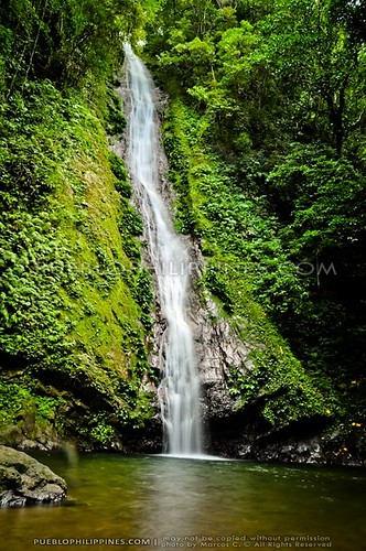
Kaibigan Falls - http://farm6.static.flickr.com/5090/5288310083_30a778ae40.jpg

PAGUDPUD

Pagudpud, a town situated 1 and a half hours north of Laoag City, the provincial capital of Ilocos Norte, and about 10 hours by land from the Philippine capital Manila, is fast gaining fame in the international travel circuit staking its claim amongst the pretenders to the throne of having the best Philippine beach which unarguably is perennially held by Boracay in Aklan. But Boracay it is not, although it comes pretty close when it comes to sand quality, the clarity of its stunningly blue waters and the length and width of its beaches (other beaches in the Philippines do have white sand, but not as fine nor the beach as long nor wide). But whilst Boracay caters to the to the party scene and its extensive range of island activities, Pagudpud derives its charm from exactly the opposite of that – even on a long weekend, the beaches of Maira-ira, Saud and Pansian rarely get the hordes of tourists that Boracay, Panglao (Bohol), and Puerto Galera (Oriental Mindoro) due to the town’s relative remoteness (although Easter Weekend is an apparent exception as told by our Korong-korong driver where the road to Maira-ira can get pretty clogged with traffic).


Pagudpud, the town, was still named as Tongotong which was then under the administrative control of the town of Bangui as being one of the barrios. And then just before the outbreak of World War II, a Batangas native, according to a local story, arrived in the area selling mosquito nets and blankets from house to house until he was totally exhausted. He sought shelter in one of the houses, hungry and tired, asking the owner of the house for a simple meal. After all had settled down, the owner asked the itinerant vendor for his purpose, and the guy, not understanding the local language merely replied, “Ako’y pagud na pagod na at ang sapatos ko’s pudpod,” in heavily Batangas-accented Tagalog meaning “I am very tired and my shoes are all worn out”. The reply became the byword of the Tongotong locals even though they themselves did not understand the meaning of what has been said. A few months later, a Bicolano (native of the Bicol Region of the Philippines) arrived to seek employment in one of the logging companies in the region (as apparently the area had thick, virgin forested mountains before and logging was still allowed by law). The guy, not knowing where the office of the company was located got off in Tongotong and asked one of the locals for the name of the place and he immediately replied, “Ako’y pagud na pagod na at ang sapatos ko’s pudpod,” as the bystander thought the man was a Tagalog and those were the only Tagalog words he knew. Our guy interpreted that the place might be called Pagud-pudpod. Tongotong became Pagud-pudpod and later shortened to Pagudpud.

But that was one story. The elders say that Pagudpud is an old Ilocano word which meant soft sandy soil “kuppuoy” a kadaratan. The majority of the population of its 20,385 residents is composed of Ilocanos, whilst a few are a collection of Apayaos, Bicolanos and Visayans.

Pagudpud’s main attractions are of course its beautiful beaches, and unlike other pretenders to Boracay’s throne, Pagudpud has every reason to believe that it does rival Boracay’s spectacular sceneries. So much so, that international travelers started to sit up and take notice. Sunday Herald Sun of Australia ranked Saud Beach as Number 1 on its list of the top ten best, lesser-known beaches of Asia besting Thailand’s Ko Adang, Sri Lanka’s Bentota, and Cambodia’s Occheuteal among others.

Pagudpud has three different beaches actually – Maira-ira Point which is also known by its moniker, Blue Lagoon and the other name Malingay Cove (It is not a lagoon – it is more like a cove), Saud and Pansian – all white sand beaches. Pansian is the furthest of the three which is almost at the border of Cagayan province and rarely gets any visitors at all, if any. The two most popular are Maira-ira and Saud. Saud is where all the resorts are, and when we say that the waters off Saud are emerald-colored even during cloudy weather or when its waves are rough– we are not kidding you. The beach is long, palm-fringed and with less people and on a clear day, one can see the Bangui windmills in the distance. The waters can be rough and dangerous during the rainy season as Saud faces the open sea and the current can be very treacherous so adequate caution and common sense are very important.

Maira-ira meanwhile has a shorter beach but has calmer waters compared to Saud. Unlike Saud with sudden drops a few meters from the shore, Maira-ira boasts of a mostly gently sloping beach into the ocean. Maira-ira is more scenic as well, the beach forming a graceful arc, with some rock formations on the right end and the islets of Dos Hermanos (Two Brothers) that seem to be guarding the cove to the left end. The main annoyance is probably the irritating sound of banana-boats in Maira-ira and the presence of some trash which we think is more or less manageable. The local government of Pagudpud should start a daily clean-up and environmental education campaigns in the area to further minimize or possibly eliminate trash in Maira-ira. The Dos Hermanos islets, which can be reached by motorized boats off Maira-ra meanwhile pride themself with their caves, rock formations, and a smattering of colorful tropical fish. The best part of the Pagudpud beaches, rarely you will get any touts at all, one can actually lie down in some corner without being bothered by anyone selling crap – better watch out for a tiny herd of goats though, cute but otherwise mostly harmless.

Aside from the stunning beaches, Pagudpud offers a lot of other attractions as well. The waterfalls of Kabigan and Saguigui on Barangay Balaoi are quite dramatic. Kabigan Falls is 80 feet surrounded by lush forest and a concave basin and practically reminds us of those picturesque waterfalls of the jungles of the Caribbean while Saguigui Falls is a smaller waterfall and very hard to get to.

Not to be outdone, Bantay Abot Caves and Timmangtang Rock in Sitio Gaoa also in Barangay Balaoi are other interesting spots in the area. Bantay Abot means “a mountain with a hole” and sometimes called “the underground sea” as there is luxuriant greenery on top of the cave. Bantay Abot Caves had a hole in the middle of the mountains where the waves crashed until it was wrecked in a massive tremor in the ‘80s. Inside the cave is a church where one can hear the echoing sound of the waves, hear the swallows that swarm in the late afternoon and other birds chirp freely. The shore of the caves has white sand mixed with shells and rocks and has quite a great view of the sea and the rugged mountains.

A few meters away is the Timmangtang Rock, a bell-shaped rock covered with vegetation and with the Bantay Abot Caves is collectively named as “Lover’s Rock” with Bantay Abot being the female and Timmangtang as the male – possibly an obvious reference to the male and female nether regions, hey?

Still on Sitio Gaoa, a panoramic view of the Pasaleng Bay, Maira-ira Point and on a clear day Babuyan Island way up north can be had at the Nacatnagan Cliff, 150 feet above sea level. As an Ilocano word meaning “fell down”, stories of Nacatnagan tell that in old times, two carabaos (Philippine water buffaloes) climbed the mountain and fell down the cliff, thus, its name. The cliff has an untouched forest teeming with wild animals, wild orchids and rare ferns along its slippery and steep slopes.


http://www.travelblog.ph/wp-content/uploads/2011/05/bangui_windmills_628_02.jpg

BANGUI WINDMILLS

The Bangui Wind Mills were built by the NorthWind Power Development Corporation to take its share in reducing the emission of harmful greenhouse gases (GHGs) causing global warming and to accelerate the rural electrification of the government.

The windmills, officially referred to as the North Wind Bangui Bay Project, was built to use renewable energy sources, thus reducing the greenhouse gases that cause global warming. The project is the first Wind Farm in the
Philippines consisting of wind turbines on-shore facing the South China Sea and considered to be the biggest in Southeast Asia. The project sells electricity to the Ilocos Norte Electric Cooperative (INEC) and provides 40% of the power requirements of Ilocos Norte via Transco Laoag.

Northwind Power Development Corp. runs the Northwind Bangui Bay Project that harnesses wind coming from the
South China Sea into electricity that helps light up Ilocos Norte in northern Luzon.

The project has been in operation since 2005, supplying the Ilocos Norte Electric Cooperative (INEC) with around 25 megawatts of power, equivalent to 40% of the cooperative’s power requirement.

Fifteen wind turbines [now 20 turbines, total is not yet confimed], each 70 meters tall, each equipped with three 41-meter blades, rise along a nine-kilometer windswept beach in
Bangui. The first of its kind in the Philippines and in Southeast Asia, they have become a tourist attraction.

The project was made "viable" because of a loan by the Danish government.
The Danish government, through the Danish International Development Agency (DANIDA), extended the firm a $29.5-million "mixed credit" or zero-interest loan. The balance of the $48-million initial investment was raised through debt and equity by Northwind Power’s shareholders.

The company has turned a profit since its wind project got off the ground, thanks to the Danish assistance in large part, as well as the appreciation of the peso and attractive tariffs in the past two years.

Wind projects normally become profitable after seven years in operation.


https://blogger.googleusercontent.com/img/b/R29vZ2xl/AVvXsEj3IGQ7erF1tIgs0GnassZPVHtE0ZkDFFzPFksHXs3B1laaUgqQ_P_BKdKTLeYx1xn-YEY85QIvo3wDfpxFWe7mVviNtv1Fflng4006eHALJDVr133aEba4kLL2n8nE49pCE2hY/s400/IMG_1640.JPG

KAPURPURAWAN ROCK FORMATION

(See image above. No information available yet as of this writing. Well, I'm sure meron. Tinatamad lang ako maghanap. Hehe!)


http://www.hotelsphilippines.org/images/stories/cape_bojeador_light_house.jpg
CAPE BOJEADOR LIGHTHOUSE

Faro de Cabo Bojeador is set majestically on top of a hill overlooking the South China Sea. Located approximately 35 kilometres north of the City of Laoag, the lighthouse is the most accessible of all lighthouses in the north of the Island of Luzon. Situated 160 metres on top of a hill named Vigia de Nagparitan, the lighthouse of Cape Bojeador serves as a station point for ships veering towards the Pacific Coast heading towards the Babuyan Channel. Similarly, it as well assists ships heading towards the ports of Salomangue in Ilocos Sur which is 87 kilometres south from the lighthouse, and Curmimao, which is 60 kilometres away in Ilocos Norte. In addition, beyond to the port of Manila. Completed on the 30th of March, 1892, the design and construction of the Lighthouse of Cape Bojeador was initially undertaken by the Engineer Magin Pers y Pers but was subsequently reconfigured and finished by the Engineer Guillermo Brockman.

The station has an arrangement that is typical of lighthouses in the Philippines with light tower, living quarters (living pavilion), serviceable apartments, and enclosed courtyard. The buildings are all erected with bricks that were baked in a kiln located at the bottom of the hill. The tower which rests on the highest portion of the hill is 16.3 metres high. The whole complex is arranged in three different levels. The lowest level contains the courtyard and service buildings, the second level, which is approximately 3 metres above the courtyard contains the main pavilion. The tower, which constitutes the highest level, is situated in the rear, five metres higher than the pavilion below. Built of locally made brick, the octagonal shaper tower has an inner dimension of two metres and an exterior dimension of three and half metres. The lower one fourth of the tower is truncated whereas the remaining body of the shaft is straight. The top of the tower supports an overhanging balcony, which is surrounded and supported by decorative grill works. The attic where the cupola and lantern rests is cylindrical. What is notable about the Bojeador Lighthouse is that is still has intact the original cupola and lantern.

The cupola, made of bronze is surrounded with glass panes. The dome on the other hand supports a ball shaped flue, which exhausts smoke from the flame of the original gaslight. The lantern on the other hand is fitted with a first order Fresnel Lens that is partially intact. “During my very first visit to this lighthouse way back in the 70’s, the original lens and mechanism was still operational. Sadly due to the intense earthquake that shook the region in 1990, parts of the lens collapsed and the alignment of the mechanism was displaced.” Nevertheless, the Coast Guards has retained the original mechanism for historic purposes and only retrofitted the lighting mechanism for its daily operations. According to the head of the Lighthouse division of the Coast Guard Commander Danilo S. Corpuz as well as Ruben R. Labuguen PCG light keeper stationed at Cape Bojeador, the Coast Guards, as well as the Department of Transportation and Communication has no plans of retrofitting the lighthouse with a new cupola and lantern due to its pristine state of preservation and the fact that it is frequented by tourists and visitors alike. In addition, due to its spectacular landscape, the lighthouse is among the most photographed and filmed of all Philippine light stations, as attested in the numerous movies shot on its location.
The mechanism fitted into the lighthouse at Bojeador was of the basic specification for all first order lighthouses. It contained a winding mechanism composed of a counter weight which when wound would enable the lantern supporting the lenses to rotate. The housing of the counter weight is located in the centre of the spiral staircase which when wound would drop all the way to the bottom of the stairs. It takes approximately one hour for the weight to reach a full cycle, which would enable the lantern to rotate numerous times. The job of the lighthouse keeper was to religiously wind the mechanism to ensure the continuous rotation of the lens throughout the night. This practice was subsequently stopped when the tower suffered damages during the 1990 earthquake.

The pavilion located below the tower is in relatively good condition. Though proper restoration of some of its architectural detailing; such as capiz and louvered windowpanes, decorative iron grilles, plastering and gutter works need immediate attention. The pavilion contains five apartments: four quarters, each provided with a separated living area, bedroom, and one watch room overlooking the Cape. A connecting hallway adjoins all the rooms except the watch room, which is accessible only through the verandah overlooking the courtyard. The lowest level of the grouping is the courtyard. In the centre of which is a well and below it the cistern, used by the keepers for their water needs. Straddling the courtyard to the east and west are the kitchens and store areas. The main gate of the lighthouse is located in the southern and western flank of the courtyard. A flight of stairs in a “T” formation directs the visitor to the pavilion. The whole lighthouse complex is accessed from the main road by a zigzag side road, which was recently widened and cemented by the Department of Public Works and Highways. A steep flight of steps leads to the lighthouse from a cul-de-sac, which marks the end of the access road.

Compared to the Lighthouse at Cape Engaño in Palaui Island, the Lighthouse in Cape Bojeador is in an envious position among Philippine Spanish Lighthouses. Not only does it protect one of the more treacherous bends of the vast Philippine coastline, but it has as well earned the distinction of being the most visited light station in the country. The lighthouse of Cape Bojeador today is not only a mere light station with an obvious functional use, its pavilion has now been transformed into a mini-museum as well as lodging for people seeking basic accommodation, though except from shared cooking facilities and water from the cistern, no other amenities are provided. Its tower is quite accessible and with little enticement from its friendly light keeper, accesses to its lantern and, if the winds are not that strong, the precarious perch from its overhanging balcony is possible. As a tourist attraction in a politically powerful province, the lighthouse of Cape Bojeador has ensured its preservation and protection for years to come. (by Arch. Manuel L. Noche)


http://www.worldtourist.us/ilocosnorte/saltmaking09.jpg
SALT MAKING IN PASUQUIN

Along the highway a few kilometers north of the town of Pasuquin, there are roadside stalls selling bags of what is arguably the finest salt in the Philippines. It is a common sight to see people riding in provincial buses that often stop at these stalls to purchase salt. Sold by the kilo and contained in plastic bags, the salt is cooked in large vats in huts which are usually found behind the stalls.

Pipes stretched from the beach to the huts carry salt water to the cooking vats. Although the initial cost of setting up and laying the pipes and then pumping salt water to the huts involves a significant amount of capital for these entrepreneurs, the convenience of having a steady supply of salt water becomes an added advantage. This process of salt making is quite different from the way salt is produced in the town of Paranaque (south of Metro Manila) where a thin layer of sea water is poured over salt beds and left to dry by exposure to the sun. However, the quality and fineness of the salt crystals made by this process does not come to par with the salt made in Pasuquin.

The salt makers of Pasuquin have improved their product by adding a minute amount of iodine to plain salt to help reduce the chance of iodine deficiency, which can lead to thyroid gland problems such as goiter. The conventional way of adding iodine to plain salt is done by using either potassium iodide or potassium iodate.
The salt makers of Pasuquin save on fuel by burning bags of sawdust during the cooking process. The sawdust, which are usually waste products in lumber yards, are now sold in sacks at minimal prices to those involved in salt making. In this cottage industry entire families are engaged in salt making, carrying on the traditional livelihood of previous generations. The Mendoza family of Pasuquin whose salt making operation I had a chance to witness is just one of the many families engaged in this cottage industry. To augment their income from selling salt, they also sell Iloko vinegar and other crops such as garlic and onions.


http://farm6.static.flickr.com/5123/5288973434_44d8427309.jpg
https://blogger.googleusercontent.com/img/b/R29vZ2xl/AVvXsEgjsgH2IhlzHp3XPRTn2ni1IUjBeWBH47f8KuLCfZLeUCuj7GqK3DG4kCtYqnzFO6PgxaKL1jsRBx6WkjhDex3ZfE444IeugrOmzJN4hcheKaIKiPscC44ALfVd-bU4EEbP9JWO1A/s400/IMG_0008.JPG
BACARRA CHURCH & BELL TOWER RUINS

The Bacarra Church together with its bell tower were constructed by the Spanish Augustinian Friars in 1593 and subsequently inaugurated in 1782. It was destroyed by the intensity 7.8 earthquake on August 1983 and reconstructed and once again inaugurated in August 1984. The image of the patron saint, San Andres, stands in front of his x-shaped cross in the central niche.

The Bacarra Bell Tower is located at the right side of the Roman Catholic Church. It was built in 1830’s and made up of coral blocks and stocco with an original height of fifty (50) meters and a three (3) storey with a wall of five (5) meters thickness. The earthquake wrecked it in 1931, which had caused the top most portions to tilt a little sideward on the right. The bell tower with its unusual elongated cupola, was built during the term of Fray Pedro Berger (1828-1848). It was made to stand a good distance from the church to reduce damage to the later in case the tower buckled during a tremor. Chunks of brick debris, hurtled down during earlier earthquakes practically at the foot of the church.

The bell tower, which is now in its advanced stage of dilapidation due to the effect of strong earthquakes, serves not only as a tourist attraction but also as a historical landmark of the painfull sacrifices of the ancestors of the Bacarenos who rendered forced labor under the Spanish conquerors.


http://zeal4adventure.files.wordpress.com/2010/03/img_8245.jpg

BANTAY CHURCH

The naming of the town as a Local Government Unit has two versions. One, some people believed that it was named ‘bantay’ after its natural and physical features, meaning, mountain, because of its hilly and mountainous terrain, particularly at its eastern portion.

Second, the other explanation is linked to the Holy Shrine of the famous and miraculous image of our Lady of Charity, which was brought to the place during the Spanish colonial period and accidentally found by fishermen on board a ship that got stranded on the shores of the Ilocos coast.

In her honor, Bantay residents built a chapel, which is now the main feature of
St. Augustine Church. It is often said that from the time the miraculous image was brought to Bantay, Tagalogs and Zambals would come to town claiming for the Holy Shrine and the image of Our Lady of Charity but even with all their might and efforts, they were not able to move nor possess the miraculous image. Instead, they left Bantay with the notion and belief that the Holy Shrine was meant purposely, and the miraculous image of the

Virgin intended to remain, for the residents of Bantay only, therein to remain forever to “guard” the place. Thus, evolved the name of the town as -BANTAY-, meaning, GUARDIAN. 


San Augustine Church and Bell Tower – one of the oldest churches of Ilocos Sur, it was built in 1590 with Fr. Montoya, as the first parish priest. The Augustinian friars named it after St. Augustine, the Patron Saint. The church was damaged during the World War II but was reconstructed in 1950. The restored facade is of neo-gothic design mixed with pseudo-Romanesque materials and elements. Its grandiose design afforded a reminiscent of the old Spanish architecture using indigenous materials, which are of bricks and slime. According to great ancestors, fishermen found the image of Our Lady of Charity placed in a wooden box floating in Bantaoay river and when the news broke, people from other towns and Provinces came to take the image but could not be moved and only people from Bantay were able to carry the miraculous image. It became the sanctuary of Our Lady of Charity on January 12, 1956, when the most Reverend Msgr. Vagnozzi, the Papal Nuncio to the Philippines, crowned the miraculous image as the Patroness of Ilocandia. The picturesque bellfry sits on a hilltop (atop the Calvario Hill) overlooking a vivid green vast of pastureland and the mountain view of the Province of Abra. It was used as a watchtower for invading enemy forces during World Wars I and II. Evidently, the Bantay Church and bell tower are the monumental witnesses to various atrocities, uprisings and staged revolts


http://farm5.static.flickr.com/4140/5220669826_c2318f896d.jpg

BAROQUE CHURCH OF STA. MARIA

Flashback with a little chunk of history, the Nuestra Senora de la Asuncion was built in 1765 under the direction of the Agustinian order, the ensemble resembles a citadel sited on the crest of a solitary hill rising above one side of the Santa Maria town plaza. The architectural ensemble presents its side and detached pagoda-like bell tower rather than its façade to the town. Thick contrafuetes (buttresses) are attached to the walls, reinforcing the structure against earthquake damage (like the buttresses in Paoay Church, Paoay, Ilocos Norte). The bell tower is constructed a distance away, protecting the main church structure from possible earthquake damage. Approached on foot by ascending a long, wide flight of piedra china, steps that rising from the edge of the town plaza, the small, cramped plaza at the top of the steps is bounded by the church façade that faces the convento, enclosed by an arcaded bridge that connects both structures.

In addition, the leaning bell tower of Santa Maria calls attention not much of its unusual location as for its proportion and hexagonal form ( which is a sight in the church surroundings). All four tiers are hexagonal and scaled in size as the tower rises making it as one of the uniformly-shaped better proportioned towers in the Ilocos. Blank walls are arranged alternately with open windows. Other decorative devices, like single pilasters, finials and balustrades indicate that this form is of later vintage.

Partly blocking the frontal view of the façade of Santa Maria Church is the convent. It is accessible from the Church by a structural bridge built over what might have been a deep channel or ditch. In the early days of the colonization, the convent was the seat of the ecclesiastical administration besides serving as a “home or retreat house of the silvery haired or aged ministers of God upon their retirements or after coming from their arduous and hazardous evangelical labors in the hinterlands.

Far to the left, passing the façade of the church a cemetery abandoned and evergreen with brush and weeds lies at the foot of the hill and connected with the church by an old and worn-out but impressive stairway now unused and all in ruins. It is perhaps the limitation of the space on top of the hill that brought about the constricted layout and construction of the Santa Maria Church.

The Our Lady of Assumption or La Nuestra Señora de la Asuncion at the side of the church was recently added and not included in the original date structure of the church. A beautiful wall sculptured painted with color that symbolizes Santa Maria the most beautiful, pretty and attractive. And as time goes by, the town came up with a tag line that goes Santa Maria a Nalibnos and that conduits to their town!


https://blogger.googleusercontent.com/img/b/R29vZ2xl/AVvXsEibkT95cAEjylDnPjo5ymb7z83SUJe39AYf0D7bO8AIexVbtijoEYJ7rzjukZgA_Dyy44fq0U8eV8D1d__9uh-pvkUA_ivAernACdwlSpA0CkOkFb-5H-dUjCVBXPE9EzYOHAdR/s1600/vigan+ilocos+sur+calle+crisologo.jpg

Syquia Mansion - http://pitchandvich.com/wp-content/uploads/2011/01/Syquia-mansion.jpg

Quema House - http://images.rally65.multiply.com/image/3/photos/21/400x400/50/83520050.JPG?et=J1sX%2BgXCzbsyi6u%2BOvKO1w
V. Singson Encarnacion House - http://a8.sphotos.ak.fbcdn.net/hphotos-ak-snc3/19959_218642812878_212570242878_3099856_4037549_n.jpg


Grandpa's Inn - http://farm6.static.flickr.com/5006/5206779012_cc166c8b96.jpg

CALLE CRISOLOGO

Calle Crisologo (also known as Crisologo Street on modern maps) can be explored purely by walking, but if you prefer, you can take a ride on one of the many kalesas (horse-drawn carriage) roaming around (this particular area is closed off to motorists). My preference was to walk around, as the street isn’t that long and I would like to take my time exploring it and the places around it (the Syquia Mansion and Crisologo Museum are not far off).
During Spain’s colonization of the Philippines, Vigan’s Mestizo District (where Calle Crisologo is located) was known as Kasanglayan (Chinese Quarters) from the word sangley which was used to classify a pure Chinese person. If a person was of an ancestry mixed between Chinese and indigenous (called indio), he was classified as mestizo de sangley, the finest example of which was Dr. Jose Rizal (it should be noted though that it was his wish to be classified as an indio instead). It was on the Mestizo District where some of these rich Chinese-Filipinos built their houses, which are still intact today and can be observed on Calle Crisologo.

Today, Calle Crisologo stands defiant amidst the technological and cultural advancements around Vigan. It is my regret that we were unable to talk a walk here at night where street lamps light the cobblestone street and a romantic Spanish-era atmosphere takes over. It could have been a great photowalk experience capturing the old street at night, but exploring that part of the city at that time was simply not on our itinerary.

Other places you might want to check out on the street are Cafe Leona (restaurant, mixed reviews) and Rowilda’s loom-weaving shop whose owners have their skills passed down to them by their ancestors.


http://www.aboutvigan.com/wp-content/themes/magazinum/scripts/timthumb.php?src=http://www.aboutvigan.com/wp-content/uploads/2011/08/St-Paul-Metropolitan-Cathedral-Vigan1.jpg&h=450&w=720&zc=1


ST. PAUL’S METROPOLITAN CATHEDRAL

Vigan Cathedral (also known as St Paul's Metropolitan Cathedral) faces Plaza Salcedo, and is an imposing creamy-white building built in the "earthquake baroque" style with thick buttresses to support it through earthquakes and typhoons. A separate belltower (or belfry) was built 15 meters away from the main building -- so that if one structure was destroyed in an earthquake, then the other might still remain standing. The belltower is about 25 meters high and it is surmounted by a large bronze weathercock that is said to symbolize St Peter.

Inside you will see an impressive altar with hammered-silver panels.

The influence of Vigan's Chinese residents on the design of the cathedral may be seen in the two fu dogs on the outer doors and in the octagonal shape of the belltower.

The first church was built on this site in 1574 (by Juan de Salcedo) and was damaged in the earthquakes of 1619 and 1627. A second was built here in 1641; and the present baroque-style church was built in the 1800s.


http://philippinemuseum.org/National%20Museum/National%20Museum%20Branches/padreburgos-house.gif

PADRE BURGOS HOUSE

This museum is the ancestral house and birthplace of priest patriot Fr. Jose Burgos. Known as Padre Burgos House, it is one of the notable historic structures of Vigan, the capital of the province of Ilocos Sur. It is a two-story structure located near the Provincial Capitol and close to St. Paul’s Metropolitan Cathedral. It was renovated by the Filipinas Foundation, Inc. and inaugurated on May 3, 1975. In January 1989, a Contract of Lease was executed by the Ilocos Sur Historical and Cultural Foundation, Inc. leasing the memorabilia for 50 years, and turning over the administration to the National Museum.

Vigan is strategically located at the delta of
Abra River and was the center of political, religious, economic, social and cultural activities in Northern Luzon for more than three centuries. This city became the hotbed of social unrest against colonial abuses. Among those who led the cause for patriotism were the Bigueños Fr. Jose Burgos, the poetess Leona Florentino, her son Isabelo de los Reyes (father of Philippine Labor Unionism) and Elpidio Quirino, the second President of the Republic.

The historic city of
Vigan was inscribed as a UNESCO World Heritage Site on December 2, 1999.

Collections
Iloco-Kankanay-Itneg material culture: wooden plates and bowls; wooden coffins; burial chair; musical instruments such as drum (tambur), bamboo mouth flute (paldeng), and brass gong (gansa); weaponry such as shield (kalasag) and spears; weaving implements and wooden loom (pag-ablan); textiles; jars.
Trade ceramics; models of two trading vessels.
Dioramas of local historical events; photographs of individuals who contributed to the socio-cultural development and history of the region and of the
Philippines.
Old books and historical records.
Memorabilia of Father Burgos and his family; period furniture pieces.
Oil paintings of the Basi Revolt of 1807 by Don Esteban Villanueva.
Liturgical collection.

Highlights of the Exhibit
The 14 Esteban Villanueva paintings of the Basi Revolt of 1807
In 14 frames, Don Esteban Villanueva, a businessman and unschooled painter from Vigan, recorded in 1821 the bloody progress of the Ilokano uprising against the Spanish government that prohibited the manufacture of ‘basiE(sugarcane wine) in the Ilocos provinces. At one time, these paintings were owned by Buenaventura Bello, former president of the Ilokano Historical Association. The paintings remained unrestored until a few years ago when a contemporary artist had been commissioned to retouch them. In spite of this, the original painter’s style is noticeable Edetails of costume and face, lack of perspective, the composition of the groups, the ominous comets, and even the little horses. The 14 oil paintings, all measuring 36 x 36 inches, was signed “E. VillanuevaE
Pag-ablan is a wooden frame loom for weaving locally grown cotton. The old backstrap loom is used although the overwhelming mass of weavers now prefers the more modern spinning wheel. Foot operates the harnesses. By moving the harnesses up and down, warp threads that are drawn through consecutive heddles of each harness form a ‘shedEthrough which the shuttle is passed. Handloom weaving became sophisticated when weavers began to use various materials, designs and colors, and became commercial. Weaving is an ancient craft among the Ilocano and a source of income for the family.

Category/Type of Museum: Art, Ethnographic


https://blogger.googleusercontent.com/img/b/R29vZ2xl/AVvXsEjyT6tTOwY0Q0K5-_LzgheBHqBtsC2Cb7W3hJv8hoh-wPyK-8aF9iLqZtR2hhRfw9f8NnJo2nDEGCaC4eWcheXFA25x5eJ4GL6zKtn8O621lMjiqF7rHGmalkDtx0SWoSRmcZxg/s400/baluarte+vigan+ilocos+sur+zoo.jpg

CHAVIT'S BALUARTE ZOO


http://static.panoramio.com/photos/original/17844373.jpg

BURNAYAN


http://farm1.static.flickr.com/65/204727321_9f04feee59.jpg

PLAZA SALCEDO


http://static.panoramio.com/photos/original/17844373.jpg

PLAZA BURGOS


http://farm6.static.flickr.com/5129/5288373903_5405da1736.jpg
MALACANANG OF THE NORTH

This imposing two-storey structure was built as the official residence of the President Marcos in Ilocos Norte. It overlooks the legendary Paoay Lake and was designed to resemble a 19th Century "bahay na bato." It is complete with bedrooms, dining area, kitchen, an office, a spacious ballroom on the second floor, and even had an olympic size swimming pool. During the term of Fidel Ramos, he has also used this former official residence in Ilocos Norte and so did President Gloria M. Arroyo whenever she travels to the north.

The main and official residence of the president of the Philippines is actually the Malacanang Palace. It is located along the north bank of the Pasig River in Manila. The name "Malacanang" comes from a Tagalog phrase "May lakan diyan," which means there is a nobleman there. This palace was once the home of a wealthy Spanish merchant before it hosted the nation's chief executive.

When Gloria Macapagal-Arroyo became the president, she opened the Malacanang of the South in August 19, 2004. It is a refurbished old building of the Bureau of Customs in Cebu City and was established to bring the national government closer to the people in the Visayas and Mindanao. In Tacloban City, Leyte, former First Lady Imelda R. Marcos had her "Sto. Nino Shrine" which also doubled as the Malacanang of the South.

Malacanang Palace of the North has since been converted into a museum and it is open to visitors. It is sad to note that the structure has not been well maintained and is now badly dilapidated. Even the swimming pool beside it is no longer used and appears to have been converted into a small fish pond. There is a mininal fee collected for those who want to see the place.


http://b5media_b4.s3.amazonaws.com/10/files/2008/04/2233065944-cd7f5160d6-paoay-church.jpg
PAOAY CHURCH

The Paoay Church was built of coral blocks and stucco-plastered bricks. Its architecture is a unique combination of Baroque and Oriental. The materials used for the walls were a mixture of coral stone and bricks. Large coral stones were used at the lower level of the walls, while bricks, smaller and more manageable to transport, were used at the upper levels. The mortar used for the coral stones and bricks points out the desire of the builders to make sure that the church stood against natural calamities. The stucco was said to have been made by mixing sand and lime with sugarcane juice, which were boiled with mango leaves, leather, and rice straw. The church is considered as one of the most striking edifices in the country with its huge buttresses flanking the sides and rear facade.

Viewed from the side, the giant buttresses look like huge volutes making the facade appear as a massive pediment rising from the ground. The facade is divided vertically by square pilasters that extend from the ground and all the way to the top of the pediment. The facade is also divided horizontally by cornices that extend all the way to the edges. The cornices extend to the sides of the church and wrap each buttresses around, adding attention and articulation to the massive side supports.

The facade is complemented with a bell tower located at its right hand side. Bell towers are a very important element in the overall composition of colonial churches, both for its function and aesthetics. For practical purposes, belltowers were used as a communication device to the townspeople. In the case of the Paoay bell tower, it also played, ironically, an explicit role in the lives of the Filipinos during the war. It has been said that the bell tower was used as an observation post by Katipuneros during the Philippine Revolution and by guerilleros during the Japanese occupation.

The Paoay Church was started by the Augustinian Fr. Antonio Estavillo. Cornerstone laying for the church was made in 1704, its convent in 1707, and the bell tower in 1793. It was completed in 1710 and nauguration ceremonies were held on February 28, 1896, just three years before the expulsion of Spanish rule in the country. The style of the church has been dubbed an “Earthquake Baroque.” The church started to be used before its completion and kept in repair by the people under the joint auspices of the Church and the town officials of Paoay. The church was badly damaged by earthquake in 1927 and lated included in the UNESCO'S World Heritage List.

Compared to its still magnificent exterior, the Paoay Church looks austere and stark inside, with but a few old images of saints and a simple wooden cross at the altar, that it is hard to imagine now how it looked like a hundred years ago. Only on Sundays does the Parish enjoy quite a number of worshippers. It is sad to note that on any other day, except for an intermittent bus loads of Taiwanese tourists, the church suffers from the lack of patronage.


http://traveleronfoot.files.wordpress.com/2009/06/sampler-10.jpg?w=470&h=352
MARCOS MAUSOLEUM & MUSEUM

The Marcos Museum and Mausoleum in Batac, Ilocos Norte showcases memorabilia of the late Philippines President Ferdinand E. Marcos and a large stately and gloomy tomb housing his embalmed remains which are contained in a vacuum-sealed glass coffin. Within the property of the Marcos family is a cluster of three houses and the hallowed grounds of the mausoleum. The Museum is the first structure seen from the main street and is the one which follows the lines of a colonial wood-and-brick house, with solid ground floor walls and an upper storey of wood decorated with floral motifs. The Mausoleum is a cube of adobe blocks and is stepped towards the top of the structure. The dark interior is divided into an entry foyer in which are exhibited old English standards and a bust of the former president.

Two decades after Marcos was chased from power, he still draws the faithful and the curious from this farming town. Displayed in an adobe mausoleum, his lavishly waxed corpse lies in a family tribute, bedecked in military medals and surrounded by faux flowers while Gregorian chants echo softly. Scores of school children visit nearly everyday, filing past souvenir peddlers for a look of the deposed dictator whom residents of Ilocos Norte province fondly call "Apo," or the Old man.


Ferdinand Edralín Marcos (September 11, 1917 – September 28, 1989) was the tenth president of the Philippines, serving from 1965 to 1986. In 1972, he instituted an authoritarian regime that allowed him to stay in power until lifting it in 1981. He was elected the same year to another full term which was marred by personal health issues, political mismanagement and human rights violations by the military. In 1986, he was re-elected for the fourth time in a disputed snap election. As a result, that same year he was removed from office peacefully by the "People Power" EDSA Revolution. He has the distinction of being the last Senate President to be elected to the presidency and being the first president to be elected to two consecutive full terms.

Ferdinand Marcos was born in Sarrat, Ilocos Norte to Don Mariano Marcos, a lawyer who was an assemblyman for Ilocos Norte, and Doña Josefa Quetulio Edralín, a teacher. He was the second of four children. His siblings were Pacífico, Elizabeth and Fortuna. He was of mixed Filipino (Ilocano), Chinese, and Japanese ancestry. He started his primary education in Sarrat Central School. He was transferred to Shamrock Elementary School (Laoag), and finally to the Ermita Elementary School (Manila) when his father was elected as an Assemblyman in the Philippine Congress. He completed his primary education in 1929.

He served as 3rd lieutenant in the Philippine Constabulary Reserve in 1937. The same year, when he was still a law student at the University of the Philippines, Marcos was indicted for the assassination of Assemblyman Julio Nalundasan, one of his father's political rivals. Marcos was convicted in November 1939. He was offered a pardon by President Manuel Quezon, but he turned it down and voluntarily returned to the Laoag Provincial Jail where he spent time preparing his defense. On appeal, he argued his case before the Philippine Supreme Court and was acquitted the following year by then-Associate Justice Jose P. Laurel. In the University of the Philippines, Marcos was a member of the Upsilon Sigma Phi. After graduating with cum laude honors in 1939, he became the topnotcher of the Philippine bar examinations the same year.


https://blogger.googleusercontent.com/img/b/R29vZ2xl/AVvXsEiqNFC5Rww3ZHVNqjb61Z85Ie5K-Gn_NHsxDzFFMMsBbCIFKEEK5qgRF36h_XXfIpRdaFMxA6wTpC06BjCvihBfkbo8QmXwN1HvkfWqcS3WNG336XxKlacqL5zYbc7dzkm3P8vzDQ/s1600/affordablevacationsinasia_philippines_ilocos+norte_currimao_coral+rock+formations.jpg
CURRIMAO

The Municipality of Currimao is located in the southwestern portion of the province of Ilocos Norte along the vast shorelines of the China Sea. It is bounded in the North by the town of Paoay, on the east by Batac, on the south by Pinili and Badoc, and on the west by China Sea. It is approximately 465 kilometers northwest of Manila and about 27 kilometers from Laoag City.

Currimao, small as it may seen, is blessed with several tourist attractions. These include the Gaang Beach Cove with its wide expanse of unpolluted beaches and tranquil waters which is a by-word of picnickers and beach lovers. It boasts also of beach resorts such as D'Coral Beach Resort and Hotel, the Old Fisherman's Beach Resort which cater to foreign as well as local tourists, and the D & D Girls Scout Beach Camp, the center of provincial and regional Girls Scouts camping and outdoor activities. The Pangil Beach Resort is where government agency outings and meetings are frequently held.

Currimao's latest tourist attraction is the Taiwanese-run Nipa Beach Resort in Barangay Salugan which caters mostly to Chinese and local tourists. A number of cottages have been constructed within the resort to accommodate its guests. It has its own restaurant, swimming pool, a well-designed and beautifully landscaped compound, and access to a nearby white sand beach. The sixteen photographs shown below were all taken at the Nipa Beach Resort.


http://www.ilocandiarealtor.com/wp-content/uploads/2010/08/juan-luna-shrine-300x225.jpg

JUAN LUNA SHRINE

The Juan Luna Shrine in Badoc, Ilocos Norte, is a reconstruction of the two-storey house in which the patriot and foremost Filipino painter was born on October 24, 1857 (The original house burned down in 1861). Luna was the son of Joaquin Luna and Laureana Vovicio. He was instrumental in placing Philippine art and culture on the world map. Luna began his formal art training at the Ateneo Municipal Escuela de Bellas Artes and Escuela Nautica in Manila. In 1877 he left for Madrid, Spain, to continue his studies at the Academia de Bellas Artes de San Fernando. It was during this period that he painted "Dafne y Chloe," which won the Silver Palette Award from the Centro Artistico-Literario de Manila.

Other major awards established Luna's reputation as a master painter both in the Philippines and Europe. These included the gold medal at Madrid's National Exposition of Fine Arts in 1884 for "Spoliarium" and a special gold medal award at the Barcelona Exposition in 1888 for "La Batalla de Lepanto," a work commissioned by the Spanish Senate. Among his notable paintings were: "The Blood Compact" and "People and Kings". Juan Luna was a co-worker of Rizal, Lopez-Jaena, Del Pilar and other Filipino reformers in Europe. He was in the Diplomatic Service of the First Philippine Republic. In 1896 Juan Luna and his brother General Antonio Luna were arrested by the Spanish authorities for subversion. During his eight months in prison he painted many canvasses, among them, "Ecce Homo," a sensitive portrayal of Christ. Luna died in Hong Kong on December 7, 1899 and his remains were interred in 1953 in niche no. 73 at the Sala de Profundis in San Agustin Church, Intramuros, Manila.

The main entrance of the Juan Luna Shrine opens into the alcove just before the family gallery. Photographs on the walls show the damaged original house and how teams of construction workers rebuilt it. In the family gallery are vintage photographs of the Luna clan, including Juan Luna's son, Andres. The museum also uses the family gallery to display household artifacts from Luna's time. Another section of the lower floor holds reproductions of Luna's two large works - "Spolarium" and "El Pacto de Sangre." There are also portraits of his wife, Paz Pardo de Tavera, and national hero Jose Rizal.

The staircase leads up to the living room, bedrooms, azotea and a mini chapel. The living room is furnished in period furniture and accessories. The master bedroom contains the four-posted bed used by Luna. Outside, facing the azotea, is the bedroom which Luna once shared with his brothers. At the grounds of the shrine is a monument of the painter.


https://blogger.googleusercontent.com/img/b/R29vZ2xl/AVvXsEgapqMnsaF3ObD9zuILDlavrBJ47BtJfd9uWVByibyT7kIeO9jftztpqhCnZGFVJcM-ovKTp1yS05NFH8QKOTvQs6w8j5BjiN2cttszERmQQOfkAvmUS4iQhbnxRKiSUzLGLxk8lg/s400/P1020342.JPG
LA VIRGIN MILAGROSA SHRINE OF BADOC

Estimated to be 400 years old, the revered image of La Virgen Milagros de Badoc is enshrined and venerated in the more than 200 year old imposing brick-and-stone baroque Catholic Church of the Parish of Saint John the Baptist in Badoc, Ilocos Norte. Inside the church one will find the miraculous image of the Virgin Mary with the infant Jesus wrapped in her arms.

Countless miracles have been ascribed to the beloved image of La Virgin Milagrosa de Badoc which have kindled and heightened the veneration and devotion of the people from the Ilocos region for which the image was really meant. Realizing the intense and widespread devotion, the Diocese of Laoag proclaimed the wooden image of La Virgen Milagrosa de Badoc as the Patrones of Ilocos Norte on May 2, 1980. This church in Badoc was the pilgrimate site for the Great Jubilee Year 2000.

Badoc is the southernmost town of the province of Ilocos Norte and lies 40 kilometers south of Laoag City. Being the gateway to the province from the south, it serves as the show window of historic Ilocos Norte. The establishment of the town as a parish in 1714 was also the approximate start of the construction of the Spanish built Catholic church, known as the Saint John the Baptist Church. It is said that the place of the Isneg settlement, wherein the first Spanish missionary team also established camp, was the seat of the Christianization of the town. It was also in the place where the church was established and where the first mass was said by Padre de Alvarado, an Augustinian priest who was the spiritual adviser of the expedition led by the youthful Spanish conquistador, Juan de Salcedo. The first mass, which was celebrated on June 24, 1572, or more than two centuries before the construction of the Catholic church, was said in thanks-giving for the peace treaty between Salcedo and the native leaders and was also dedicated to those who were slain in battle. It coincided with the feast day of Saint John the Baptist, who was made Badoc's patron saint.

Folks recounted that the huge and imposing house of worship, made of bricks and stones and roofed with Spanish-style corrugated clay tiles, was constructed under the Spanish forced labor decree. It was also said that not a single drop of water was used in the whole construction process. The concreting materials were made purely of sugarcane juice, which the natives contributed under the "family quota system." Now, the church, already weather-beaten but unweakened by time and age is the sanctuary and shrine of La Virgen Milagrosa de Badoc, because it was found in the year 1620 by Badoc and Sinait fishermen along the shore of Lugo village. The image, encased in a wooden box, together with a life-sized picture of Santo Cristo Milagroso, the statue of angels and one violin, were given to the Sinait fishermen as their share from the mysterious discovery, Since, then, the Sinait Catholic church has become the shrine of the Santo Cristo Milagroso.